The recent floods have devastated Queensland, with 35 flood-related deaths since November 30. Much of the region is littered with mud and debris. Victoria too, is battling, with two thousand properties experiencing flood damage. The focus is now shifting from immediate clean-up to asking: what caused these floods? Climate change? Freak weather?
According to meteorologists, the flooding we’ve witnessed is a symptom of a natural weather phenomenon called La Niña. In a recent Crikey piece, Dr David Jones, head of climate monitoring and prediction at the Bureau of Meteorology, said we’re in one of the strongest La Niña periods in modern history. So what exactly is La Niña?
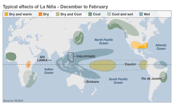
La Niña in a nutshell La Niña is Spanish for “the girl-child.” The term is used to describe the cyclical cooling of the central and eastern Pacific Ocean.
La Niña is the lesser known sibling of El Niño, which means “the boy-child.” While El Niño often results in strong warm weather in the Pacific — which can trigger drier conditions in eastern Australia — La Niña is associated with wetter than normal conditions. The presence of La Niña often means the east coast of Australia and parts of Southeast Asia will see more rain, flooding, monsoons and possibly cyclones.
La Niña is also known as anti-ENSO (anti-El Niño Southern Oscillation) since it’s the opposite of an El Niño episode.
During a La Niña period, surface temperatures in the western Pacific Ocean are typically warmer than usual, whereas in the east the water is abnormally cool. This cool water pools along the west coast of South America, where it is eventually pulled across the Pacific, towards the west, by strong easterly winds.
This surge of cool water pushes the warm waters in the western Pacific up against Australia’s east coast and the Southeast Asia region. The warm water accumulates, which changes pressure in the atmosphere and usually heavy rainfall occurs as a result.
This year’s La Niña was unexpectedly severe. According to BBC meteorologist Laura Tobin, it’s likely La Niña even had an effect on the recent flooding in Sri Lanka which killed 40 people and displaced over a million. La Niña’s easterly winds don’t normally extend as far west as Sri Lanka, but this year winds wreaked havoc when they converged with the region’s naturally occurring northeast monsoon.
La Niña has visited Australia before, most notably during 1973-74. On Australia Day of 1974 Brisbane and Ipswich were swamped by a catastrophic deluge which took the lives of 14 people and was widely considered as Brisbane’s worst flooding of the 20th century.
Recent La Niña years also include 1988-89 and 1998-2000. On both occasions the country saw high levels of rainfall, with 2000 being our second wettest year on record. According to the Annual Australian Climate Statement 2010 by the Bureau of Meteorology, last year was Australia’s wettest year since 2000, and it was the wettest year for Queensland.
1974 remains Australia’s wettest year on record.
What can we expect from La Niña next? La Niña cycles typically last up to 12 months and this year’s is expected to dissipate by March or April. Until then it’s expected higher than average rainfall will continue to fall across eastern New South Wales and southeastern Queensland.
La Niña hasn’t been bad news for everyone. The ABC reports that farmers in Western Australia are welcoming the rainy weather. According to weather predictions, WA has a 60 to 75 per cent chance of exceeding its average rainfall over the coming three months.
If forecasts are correct, the extra rain will help WA farmers have a better cropping season in April and May.
But elsewhere in the world people are still recovering from the devastating force of La Niña. Many thousands in Brazil, the Philippines, Sri Lanka and Australia are in the process of rebuilding their lives. There’s no doubt that this year’s La Niña was extreme, and an event which we will hopefully not see the likes of again.
Roselina Press is a volunteer for Oxfam Australia and editor of the A Climate for Change website. First published on Crikey